
By Saroj KC
On the morning of 26 August 2026, a disaster began high in the mountains of Rasuwa that would become one of Nepal’s most devastating natural catastrophes in recent history.
It was not an ordinary monsoon flood.
A massive collapse on the northern face of Langtang Lirung, followed by an ice-rock avalanche and debris flow, sent an enormous mixture of rock, ice, mud and water into the Lhende Khola and then into the Bhotekoshi and Trishuli river system. Communities, roads, bridges, hydropower projects and border infrastructure were overwhelmed within minutes.
More than a month later, the physical destruction is visible. But the deeper questions remain: Could the disaster have been detected earlier? Was Nepal prepared? What role did climate change play? And what should be done before another mountain hazard becomes another national tragedy?
What actually happened?
According to the International Centre for Integrated Mountain Development (ICIMOD), shortly after 8:37 a.m., a large section of rock and glacier ice broke away from the north face of Langtang Lirung, a 7,227-metre mountain in Rasuwa. Source: ICIMOD event assessment and published Q&A.
The material fell roughly 1,200 metres into the Lhende Khola, breaking apart and mixing with water, rocks and sediment. The resulting debris flow then moved into the Bhotekoshi River near the Rasuwagadhi–Gyirong border before travelling downstream through the Bhotekoshi and Trishuli corridors.
This distinction is important.
The disaster is sometimes described simply as a glacial lake outburst flood (GLOF). Technically, however, the evidence currently points to something different: an ice-rock avalanche that transformed into a massive debris flow. There was no lake at the point of origin that suddenly emptied.
In other words, the flood came from a mountain collapse not simply from a river overflowing after heavy rain.
It was not a normal rain-driven flood
One of the most important findings is that rainfall does not explain the scale of the disaster.
ICIMOD’s assessment says rainfall and river-gauge observations did not show the kind of heavy rain that could have produced such a huge surge.
That created a major challenge for conventional flood-warning systems.
A system designed primarily to detect rising river levels or heavy rainfall can struggle when the danger originates suddenly thousands of metres above the valley.
This is one of the most important lessons from Rasuwa: a Himalayan disaster does not always announce itself through rain.
Why was the destruction so extreme?
The geography of the region made the situation particularly dangerous.
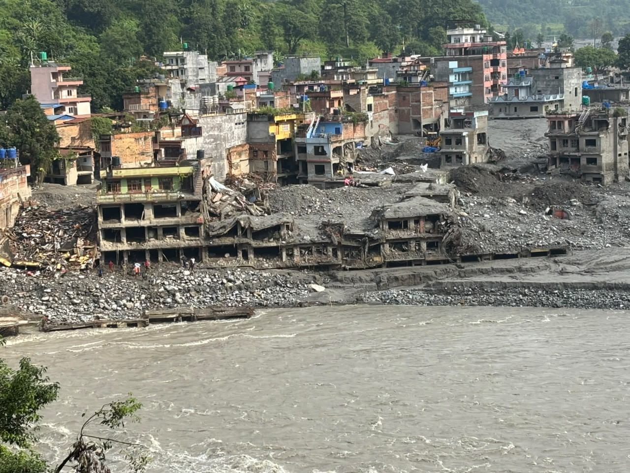
The enormous volume of rock, ice, water and sediment entered a narrow mountain river system and travelled downstream with extraordinary force. At settlements and infrastructure located close to the river, there was very little time to react.
Rasuwagadhi and Timure were among the hardest-hit areas. Roads, bridges, buildings, vehicles, border facilities and hydropower infrastructure were swept away or buried.
The damage did not stop in Rasuwa. The flood moved through the Bhotekoshi–Trishuli corridor, affecting communities and infrastructure farther downstream.
Nepal’s preliminary disaster assessment estimated more than NPR 408 billion in damage and losses, while recovery and reconstruction needs were estimated at about NPR 723.31 billion. The assessment recorded damage to 7,570 private houses, 37 motorable bridges, 68 suspension bridges and 69 kilometers of roads, along with major losses in energy infrastructure.
These numbers explain why this was not simply a local disaster.
It was an infrastructure, economic and humanitarian crisis.
The human cost is harder to measure
The most painful part of the disaster is not the destroyed infrastructure. It is the people who disappeared.
Official figures changed repeatedly as rescue and identification operations continued, and different agencies published different totals. Nepal Police bulletins reported the recovery of bodies from districts along the corridor — including areas far downstream of Rasuwa — while the National Disaster Risk Reduction and Management Authority (NDRRMA) published situation reports with casualty, missing and rescued totals that were revised as recovery work continued. Source: NDRRMA situation reports; Nepal Police bulletins as reported by national media.
By September, thousands of people were still officially listed as missing, while many recovered bodies remained unidentified.
The identification process has been especially difficult.
Bodies were recovered from different locations, some far from where people were last seen. DNA samples were collected from unidentified remains and relatives of missing people, but identification has taken time.
For many families, the disaster therefore did not end when the floodwaters disappeared.
They are still waiting for an answer.
What about the China warning controversy?
Almost immediately after the disaster, questions emerged about whether China had warned Nepal.
This issue needs to be handled carefully.
There were reports of weather-related information and communication between the two countries before the disaster. But a general weather warning is not the same thing as a scientifically reliable prediction that Langtang Lirung would collapse at a particular time. ICIMOD’s own published Q&A states that the trigger point on Langtang Lirung lay inside Nepali territory, which is why the collapse fell outside monitoring and warning systems built around the Chinese side of the border. Source: ICIMOD, Kyirong–Rasuwa flood Q&A; ICIMOD expert commentary reported by international media; Chinese Embassy public notices as reported in the Nepali press.
There is currently no sound basis for simply stating that China knew the mountain would collapse and deliberately failed to warn Nepal.
There is another important fact: the trigger point identified by ICIMOD was on the Nepal side, at Langtang Lirung. The resulting debris flow then moved through a border river system and severely affected both Nepal and the Chinese side.
That does not mean cross-border communication is unimportant.
Quite the opposite.
Mountain hazards do not respect political boundaries. Nepal, China and other Himalayan countries need faster mechanisms for sharing satellite observations, river data, seismic information and mountain-risk alerts.
The lesson should therefore be better cooperation, not unsupported accusations.
What about the earthquake theory?
Another early explanation suggested that an earthquake had triggered the disaster.
Later analysis showed that the seismic signal associated with the event was closely connected to the mountain collapse itself.
That is an important distinction. The signal that looked like an earthquake was not necessarily evidence that an earthquake caused the flood. The collapse itself generated seismic energy that could be detected by monitoring networks.
Other questions remain under scientific investigation, including the precise sequence of the mountain failure and whether earlier instability played a role.
The responsible position is to distinguish between what scientists have established and what they are still investigating.
Did climate change cause the disaster?
It would be too simple to say that climate change alone caused the Rasuwa flood.
Mountain collapses are influenced by many factors: geology, fractured rock, ice conditions, temperature, slope stability, water and possibly previous seismic disturbance.
But climate change is clearly part of the wider risk.
The Himalayas are warming, glaciers are retreating, and frozen ground that can help stabilize steep mountain slopes is becoming increasingly vulnerable.
That does not mean every avalanche or flood can be directly labelled a “climate-change disaster.”
It means the background conditions are changing, and Nepal must plan for a future in which some mountain hazards may become more difficult to predict.
Did Nepal’s response fail?
The answer is more complicated than either “yes” or “no.”
Nepal mobilized the Army, Nepal Police, Armed Police Force, helicopters, medical teams and other resources. Thousands of people were rescued and evacuated.
But the disaster also exposed serious weaknesses.
Roads and bridges were destroyed. Communication systems were disrupted. Hydropower tunnels became extremely difficult to access. Rescue teams faced dangerous terrain, huge amounts of debris and limited access to specialized equipment.
Reports also highlighted the difficulty of locating workers trapped at hydropower projects.
The lesson is not that rescuers did not work hard.
The lesson is that a rescue system can only be as effective as the infrastructure, information and equipment available to it when the disaster strikes.
Nepal needs to prepare before the emergency not improvise everything after it begins.
What Nepal must change
The biggest lesson from Rasuwa is that Nepal needs to move from disaster response to disaster anticipation.
First, monitoring must improve.
High-risk mountain slopes, glaciers and glacial lakes need better satellite observation, ground sensors, cameras and other monitoring technologies.
Second, early-warning systems need to become more sophisticated.
A warning system cannot depend only on rainfall and river levels. It must also consider sudden mountain collapses, debris flows and other cascading hazards.
Third, cross-border information sharing must become faster.
A mountain event in one location can become a river disaster hundreds of kilometers away. Nepal needs reliable, real-time channels with neighboring countries and international scientific institutions.
Fourth, infrastructure planning must change.
Roads, bridges, hydropower projects, settlements and border facilities should be designed with realistic consideration of downstream hazard zones.
Rebuilding exactly what existed before is not necessarily recovery.
Sometimes it is simply rebuilding the same vulnerability.
Nepal is already looking toward the next threat
The government has now announced plans to reduce the risks from four high-altitude glacial lakes-Thulagi, Lower Barun, Lumding Tsho and Hongu II.
The proposed programme, backed by international climate and development financing, includes controlled drainage, sensors, flood forecasting and community preparedness.
That is an important direction.
But the programme should not become another plan that exists mainly on paper.
The Rasuwa disaster showed how quickly a hazard can move from an inaccessible mountain slope to populated areas.
Preparedness must therefore reach the people who live and work downstream.
Communities need clear evacuation routes, simple warning procedures, drills and designated safe areas.
Hydropower companies, transport operators, schools and local governments should know what to do when a warning arrives or when warning time is almost nonexistent.
The real lesson from Rasuwa
The Rasuwa disaster has already generated political arguments, rumors and competing explanations.
Some questions will take months or years of scientific investigation to answer.
But some lessons are already clear.
The disaster showed that Nepal’s mountains can generate hazards faster than conventional warning systems can respond.
It showed the enormous cost of building critical infrastructure without fully accounting for cascading mountain risks.
It showed the importance of scientific evidence in an environment where rumors can spread faster than facts.
And it showed that disaster preparedness cannot be treated as a secondary government responsibility.
Nepal cannot stop every landslide, avalanche or mountain collapse.
It cannot control the climate.
But it can improve monitoring. It can strengthen warning systems. It can share information faster. It can train rescue teams better. It can build infrastructure more intelligently. And it can listen more seriously to communities living beneath the mountains.
The Rasuwa flood was not simply a flood.
It was a warning about how quickly a mountain hazard can become a national disaster.
The mountains have already given Nepal the warning.
The question now is whether Nepal will learn from it.
Editor’s Note
This article distinguishes between established findings, reported facts and issues that remain under scientific investigation. Where the evidence is still developing, the article avoids presenting speculation as fact. Claims about causes, casualty figures and warnings are attributed to the named source so readers can check them directly.
How this article was researched
- Cause and sequence of the event: the International Centre for Integrated Mountain Development (ICIMOD), which published a technical Q&A and event page for the Kyirong–Rasuwa flood, including the 08:37 am failure time, the Langtang Lirung source area, the rock–ice avalanche mechanism and the finding that rainfall and river gauges did not explain the surge.
- Casualty, damage and response figures: Nepal’s National Disaster Risk Reduction and Management Authority (NDRRMA) situation reports, and Nepal Police bulletins as reported by national media. These figures changed repeatedly, and different agencies counted differently — which is why the article describes them as official but evolving.
- Border, warning and cross-border questions: ICIMOD statements, the Government of Nepal’s damage assessment, and reporting by Reuters and the Associated Press.
- Chinese-side impact and the early-warning discussion: ICIMOD expert commentary and the Chinese Embassy’s public notices as reported in the Nepali press.
Sources and Further Reading
- ICIMOD — Kyirong–Rasuwa Flood 2026 event page and Q&A (technical assessment, 26 August 2026)
- ICIMOD — press release: major flash flood sweeps through Nepal’s Rasuwa district
- ICIMOD — Learning from disaster: international experts convene after the Rasuwa Gyirong flood (16 September 2026)
- NDRRMA — Rasuwa–Bhotekoshi flood search, rescue and relief situation report (PDF, 1 September 2026)
- The Kathmandu Post — Rasuwa flood death toll climbs to 95 as dozens remain missing (26 August 2026)
- The Kathmandu Post — major flood damages Syabrubesi hydropower projects in Rasuwa (26 August 2026)
- Al Jazeera — reports of a barrier lake and rising water after the flood (28 August 2026)
- Axios — what caused the Nepal flood, and the early-warning questions (29 August 2026)
- Nepal Police — official bulletins and public statements
- Department of Hydrology and Meteorology, Nepal — rainfall, river-gauge and flood monitoring
A note on numbers: casualty figures in a disaster of this scale are provisional, and different agencies published different totals as recovery and identification continued. Where this article gives a figure, it names the source and treats the number as a snapshot rather than a final count.
Community discussion
Comments 0
Comments are reviewed before they appear publicly. Be respectful and avoid sharing private information.
No approved comments yet. You can be the first to share a useful thought.
Add a comment
No account or login is needed. Your comment is emailed for moderation and is published only after approval in the CMS.